


وصف لـ Geography: Countries of the world. Flagmania!
This is a quiz about geography, it has a lot of interesting things:
- The capitals of the countries of the world,
- Flags of the world,
- The population of countries,
- Area of countries
- Independence Day.
Also in the game there is a "World Map"
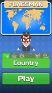
A fun Flagsman assistant will guide you through the game. He in a fun way will tell interesting news from around the world. Will conduct a geography test. Will be happy for every level you completed.
In the capitals of the world - it is necessary to guess the country that corresponds to the capital.
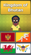
In flagmania - you need to guess the flag corresponding to the country.
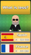
Population - you need to guess the smallest country.
In area mode - you need to guess the largest country by area.
Independence Day of the country - historical geography, you must check the information on the date of independence of the country and choose - true or false.
The capitals of Europe, the capital of Asia and other parts of the world. You can very effectively learn the capital, because our app have geography encyclopedia. In general, all political geography is divided not by continent, but into the cognitive parts of the world. Geography map:
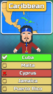
Africa, Eurasia: Asia - Europe, Australia, Oceania: Polynesia - Micronesia - Melanesia, Caribbean, South America, North America.
In order to play it was more interesting, the game has one hint, which removes half of the wrong answers.
The game itself has informative information about countries and geography knowledge, as an example:
Until 1800, the capital of the United States was Philadelphia.
Levels consistently open up new countries and its flags:
1) USA, France, China, England, Spain and Colombia
2) Australia, Russia, Poland, Canada, Israel and Mexico
3) Cuba, Madagascar ...
8) Ukraine, Austria, Barbados, Tunisia, the Marshall Islands ...
Available languages:
English;
Russian;
Ukrainian;
Deutsch;
Spanish;
Chinese simplified;
Polish;
Portuguese;
French;
Japanese;
All modes are created entertaining, like educational games for children. Modes become available gradually, first the questions are easy, and then the tasks are more complicated. Geographie game - for you, geography kid for your kids!
Countries from all continents:
Countries in Africa;
Countries in Europe;
Countries in Asia;
Countries in Oceania;
Countries in North America;
Countries in South America;
Geography learning is an interesting and useful thing:
Population of Spain is less than population of Colombia!
Memory training in flags and countries provided!
Start learning countries and capitals now!
You will be able to learn the flags of the world!
You can easily improve your knowledge in the field - Geography national.
Have a nice and educational game, geography now!
هذا هو اختبار حول الجغرافيا ، لديه الكثير من الأشياء المثيرة للاهتمام:
- عواصم دول العالم ،
- أعلام العالم ،
- سكان البلدان ،
- منطقة البلدان
- يوم الاستقلال.
أيضا في اللعبة هناك "خريطة العالم"
سوف مساعد Flagsman متعة يرشدك من خلال اللعبة. إنه بطريقة ممتعة سوف يخبر أخبار مثيرة للاهتمام من جميع أنحاء العالم. سيتم إجراء اختبار الجغرافيا. سيكون سعيدا لكل مستوى الانتهاء.
في عواصم العالم - من الضروري تخمين البلد الذي يتوافق مع العاصمة.
في flagmania - تحتاج إلى تخمين العلم المطابق للبلد.
السكان - تحتاج إلى تخمين أصغر دولة.
في وضع المنطقة - تحتاج إلى تخمين أكبر دولة حسب المنطقة.
يوم استقلال البلد - الجغرافيا التاريخية ، يجب عليك التحقق من المعلومات حول تاريخ استقلال البلد واختيار - صحيحة أو خاطئة.
عواصم أوروبا ، عاصمة آسيا وأجزاء أخرى من العالم. يمكنك تعلم العاصمة بفعالية كبيرة ، لأن تطبيقنا يحتوي على موسوعة جغرافية. بشكل عام ، كل الجغرافيا السياسية لا تقسمها القارة ، بل إلى الأجزاء المعرفية من العالم. خريطة الجغرافيا:
أفريقيا ، أوراسيا: آسيا - أوروبا ، أستراليا ، أوقيانوسيا: بولينيزيا - ميكرونيزيا - ميلانيزيا ، الكاريبي ، أمريكا الجنوبية ، أمريكا الشمالية.
من أجل اللعب كان أكثر إثارة للاهتمام ، فإن اللعبة لديها تلميح واحد ، والذي يزيل نصف الإجابات الخاطئة.
تحتوي اللعبة نفسها على معلومات مفيدة حول البلدان والمعرفة الجغرافية ، على سبيل المثال:
حتى عام 1800 ، كانت عاصمة الولايات المتحدة فيلادلفيا.
تفتح المستويات باستمرار البلدان الجديدة وأعلامها:
1) الولايات المتحدة الأمريكية ، فرنسا ، الصين ، إنجلترا ، إسبانيا وكولومبيا
2) أستراليا وروسيا وبولندا وكندا وإسرائيل والمكسيك
3) كوبا ، مدغشقر ...
8) أوكرانيا ، النمسا ، بربادوس ، تونس ، جزر مارشال ...
اللغات المتوفرة:
الإنجليزية؛
الروسية؛
الأوكرانية.
الألمانية؛
الأسبانية؛
الصينية المبسطة؛
تلميع؛
البرتغالية؛
فرنسي؛
اليابانية؛
يتم إنشاء جميع وسائط مسلية ، مثل الألعاب التعليمية للأطفال. تصبح الأوضاع متوفرة تدريجياً ، أولاً تكون الأسئلة سهلة ، ثم تكون المهام أكثر تعقيدًا. لعبة الجغرافيا - بالنسبة لك ، طفل الجغرافيا لأطفالك!
دول من جميع القارات:
دول في افريقيا
دول في أوروبا
دول في آسيا
بلدان في أوقيانوسيا ؛
بلدان في أمريكا الشمالية ؛
بلدان في أمريكا الجنوبية ؛
تعلم الجغرافيا شيء مثير للاهتمام ومفيد:
عدد سكان إسبانيا أقل من عدد سكان كولومبيا!
تدريب الذاكرة في الأعلام والبلدان المقدمة!
ابدأ في تعلم البلدان والعواصم الآن!
سوف تكون قادرة على تعلم أعلام العالم!
يمكنك بسهولة تحسين معرفتك في هذا المجال - الجغرافيا الوطنية.
هل لديك لعبة جميلة والتعليمية ، والجغرافيا الآن!
Geography: Countries of the world. Flagmania! - إصدار 0.903
(29-02-2024)Geography: Countries of the world. Flagmania! - معلومات APK
نُسخة APK: 0.903الحزمة: com.bedrill.quiz.flags.capitalsتطبيقات من الفئة نفسها
قد يعجبك أيضًا...


